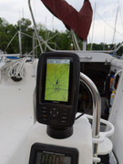
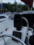
Garmin Echomap 43CV Chartplotter with US Inland Lakes Maps and an ICOM IC-m94D Handheld VHF. (300+300$)
-chartplotter has rapid GPS acquisition, excellent daytime visibility, accurate to my slip spot in my marina. , installed to my pedastal ran the 12V cable down thru the transom and under the port aft bed. Took about 18ft of wiring.
-took about 90minutes including me having to recrimp a few connections.still using my old standard horizon depth finder for now, I haven't installed the transom mounted depth finder for the garmin
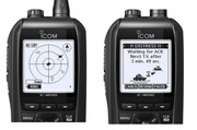
The Icom M94D has DSC and receives AIS. AIS may be overkill but could be useful for great lakes (Erie).
That's a nice setup. I'm going to upgrade my depthfinder display soon. I mounted a Garmin gpsmap 741 (i bought it used a couple years ago and was too big for my 26D) in the same spot as yours and it works great, but I wish it had sonar/fishfinder too instead of having a separate display for depth.
When i bought my vhf a few years ago, I considered getting the next step up VHF radio with AIS but didn't feel the cost justified it. If Lake Erie conditions are bad enough that I can't see ships, I won't be out there!
Where in Ohio do you sail out of? I'm planning on helping a friend sail his c&c 29 from Cleveland to Erie this weekend.
1987 26D - Three Hour Tour; 1998 26X - to be named
Nice setup! How useful do you find the AIS display? Does it have collision warnings? I just got a new SH handheld that I really like so not in the market for a new handheld but I am thinking of getting an a SH Matrix 2400GX (my current fixed VHF doesn't seem to transmit for some reason) and outputting the AIS signal to my tablet running Navionics using something like the Yakker.
I wasn't sure until you asked that question but it has a "danger list" of vessels that are targeted to their "closest point of approach" range that is set. It gives you distance to the CPA as well as time!!! Wow!
The screen is fairly basic but likely adequate for avoiding big Lakers.
Besides letting you know where the big fellows are, AIS also let's them know where you are. A Mac is a tiny spec to them, and if you are close enough, (as in coming up behind you) you will fall under their radar.
NiceAft wrote: ↑Fri Jun 04, 2021 10:11 am
Besides letting you know where the big fellows are, AIS also let's them know where you are. A Mac is a tiny spec to them, and if you are close enough, (as in coming up behind you) you will fall under their radar.
I may have missed it, but I don't think any of the AIS devices that have been mentioned so far are transmitters. They are all receive-only. If you want them to see you you will need to be transmitting as well.
Even a much larger fiberglass boat will have a very small radar return unless it has a radar reflector. Even then it's hard to see in rough weather.
Bill
2001 26X Simple Interest
Honda BF40D
"If I were in a hurry I would not have bought a sailboat." Me
Correct mine is receive only. I would need a transmitter which doesn't existing a handheld to my knowledge. Will certainly investigate pending future plans
I’ll never forget shooting out on Lake Ontario under perfect beam reach conditions, eating pizza and wine, then wondering why that tanker was so close to shore we could see his red and green.
Hmmm. 2 hours at 7 knots, we were halfway to Toronto in the middle of a shipping channel.
Just finished a week up in the Western Islands using the chartplotter. I would say it was a great addition and helped maximize our time on the water. Also felt safe knowing where we were in relation to weather coming in.