

I am new to the East Coast, and although I have located some launch ramps, I'd like to know if anyone has come upon a great reference for ramps starting in the DelMarVA region particularly, but we plan on being on the road as much as we can this upcomming season, so why not plan ahead. We have done some sailing on the Susquahanna River, but it is shallow. I have been at the ramp on the Delaware River, under the Commodore Perry Bridge, but even though it is beautiful, the area it's in makes me leery, as far as security in Chester, PA. It is the closest from us though for a large body of water. We are located very close to Hershey PA now.
We have only started this process by locating ramps and Kayaking them for accessability etc., so far, but I have upgraded this Mac so much I need to get out!
If someone can reccomend a Smart Phone and application for ramps that would be great as well, as we will be upgrading very soon.
Also is there a particular Chart Plotter you use that works good for what I am seeking?
A website would be golden as well. We will be sailing Mystic Harbor area, New York Harbor, and possibly making our way to Fla., East coastal region eventually. I will be pulling with an R.V., so we may be out for a month or more at a time, depending.
I know I am spoiled, as San Diego ramps were abundant, in great shape.....and free!
Anyway, if a database exists, I'd sure like to find one!
I Have 2 GPS devices currently, but have found nothing to give me this capability. The Iway 600C has been pretty good and has a Chart Database and not much else. I just picked up a Garmin NUVI 2460LMT and doubt I'd get any satisfaction there either, unless someone knows a link that may help perhaps?
A Paper Chart is the good O'l standby, and if someone knows of an East Cost Atlas Style for sale, I'd like one of those as well!
East Coast launch ramps ?
-
c130king

- Admiral
- Posts: 2730
- Joined: Sun Nov 05, 2006 5:30 pm
- Sailboat: MacGregor 26M
- Location: Wiggins, MS --- '05 26M "König" w/ 40hp Merc
- Contact:
Re: East Coast launch ramps ?
http://www.activecaptain.com
Click on the "The Interactive Cruising Guidebook" tab at the top.
The use the map controls to zoom in on the area you are looking at. If you zoom out too far you may have so many markers they turn themselves off...just zoom in a little. And you can have the "map view", the "NOAA Chart View" or even "satellite view". Pretty cool.
If you like you can click on the four colored squares (top left) to limit the number of markers. Red = Marinas, Blue = Ramps (and local knowledge), Green = Anchorages and Orange = Hazards. If you have too many markers click on the squares to hide that color markers.
Click on a marker on the map and window opens up with additional info on that marker.
Many will have "reviews" that you can look over and see what others have said...register and add your own.
Great website for trip planning.
Cheers,
Jim
ON EDIT: There is an "app" for this but it is not nearly as easy to use as the website. But the app will work like a chartplotter if your device has GPS.
-
Norca

- Engineer
- Posts: 149
- Joined: Sun Sep 05, 2010 5:05 am
- Sailboat: MacGregor 26M
- Location: Iles De La Madeleine Quebec Canada
Re: East Coast launch ramps ?
I agree about activecaptain, it's a great website for trip planning.
I am using it right now to plan a trip to Long Island Sound and New York in may-june,
It has a wealth of information.
The Trailer/Sailors Association seem to have a list of launch ramps for members only on this site: http://www.trailersailors.org/webpage/11
I'm not a member myself, so I don't really know but worth checking out.
-
Sumner

- Admiral
- Posts: 2375
- Joined: Sun Jan 04, 2009 3:20 pm
- Sailboat: MacGregor 26S
- Location: SE Utah
- Contact:
Re: East Coast launch ramps ?
Have you looked at or considered the free chart plotting program SeaClear that uses the free NOAA charts? We have it on the ship's computer and on two laptops we have with us and I also have in on the desktop at home. A great resource to use at home for planning or when someone mentions an area and it is what we use on the boat for 'real time' chartplotting and navigation. We love it and it has been invaluable to us.Tom Root wrote:....Also is there a particular Chart Plotter you use that works good for what I am seeking?.
Here are a couple screen shots...
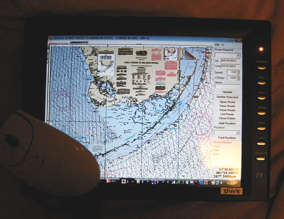
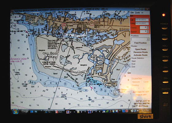
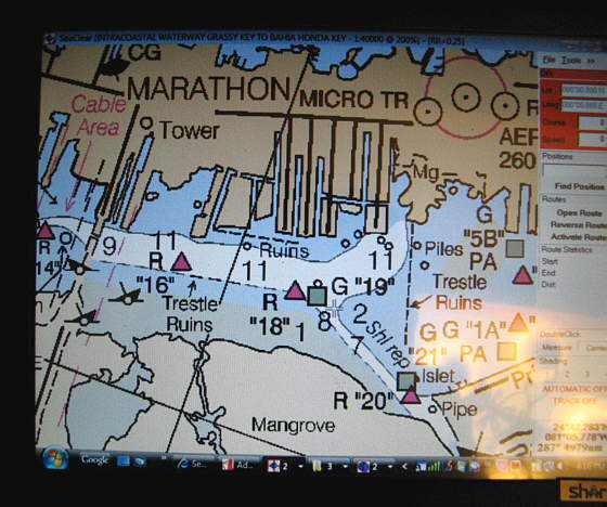
More on it here....
http://purplesagetradingpost.com/sumner ... lot-1.html
...with links as to where to download it and also a link to the NOAA charts.
You can setup a route in minutes and download the waypoints into a handheld or setup a cockpit display or use the computer below,
Sum
Our Endeavour 37
Our Trips to Utah, Idaho, Canada, Florida
Our MacGregor S Pages
Mac-Venture Links
-
Tom Root

- Captain
- Posts: 560
- Joined: Mon Jan 05, 2004 11:39 pm
- Sailboat: MacGregor 26X
- Location: Annville, PA. s/v-Great White, MacX4787A202,'09 Suzuki DF-50
Re: East Coast launch ramps ?
These are some excellent references, thanks! I didn't notice the Mac Map stickie, at the top of this page, but it looks good too, if I can figure it all out? 
-
hoaglandr
- Engineer
- Posts: 155
- Joined: Sat Aug 21, 2010 8:23 am
- Sailboat: MacGregor 26M
- Location: Springfield, Ohio - 2005 M: LazyDayz - Yamaha T50
Re: East Coast launch ramps ?
Active Captain is a great free resource. I also picked up the Navionics app for my iphone. It has access to nautical charts and includes all the active captain markers. As an aside - Active Captain has just released another free iphone app - "Drag Queen" - an anchor alarm.
Russell
Russell
-
Erik Hardtle

- First Officer
- Posts: 408
- Joined: Sat Jan 03, 2004 4:45 am
- Sailboat: MacGregor 26X
- Location: New Bern, NC
- Contact:
Re: East Coast launch ramps ?
This has all the Wildlife Resources Commission Boating Access (Free Ramps) Areas for North Carolina.
http://216.27.39.120/mapbook/boataccess.aspx
http://216.27.39.120/mapbook/boataccess.aspx
-
Catigale

- Site Admin
- Posts: 10421
- Joined: Fri Jun 11, 2004 5:59 pm
- Sailboat: MacGregor 26X
- Location: Admiral .............Catigale 2002X.......Lots of Harpoon Hobie 16 Skiffs....Island 17
- Contact:
Re: East Coast launch ramps ?
Welcome out east Tom.
Several helpful Maccers in eastern PA who I'm sure will chime in after the Xmas festivities today.

Several helpful Maccers in eastern PA who I'm sure will chime in after the Xmas festivities today.
-
Laika 26X

- Engineer
- Posts: 159
- Joined: Mon May 11, 2009 12:42 pm
- Sailboat: MacGregor 26X
- Location: Homeport: Mt Sinai, NY - Homewaters: Long Island Sound, Northeast USA
- Contact:
Re: East Coast launch ramps ?
Tom,A website would be golden as well. We will be sailing Mystic Harbor area, New York Harbor, and possibly making our way to Fla., East coastal region eventually. I will be pulling with an R.V., so we may be out for a month or more at a time, depending.
LAIKA is out of Mt Sinai Harbor, which is midway out on the north shore of Long Island, great as a base for cruising Long Island Sound. Plenty of gunkholing on both the north shore of Long Island AND Connecticut's South Shore. Mystic Harbor is some 54 nm from me, 10 hours with the tides favor. I plan to do a LOT of exploring here, NYC (what a night sail!!), South Shore (The Great South Bay, my previous stomping grounds and perfect for the
While I'll be at a mooring this year, as I tend to not trailer her, I can say Brookhaven Town's Ramps at Mt Sinai are excellent, thought they charge a hefty $25 usage fee. But I don't think it would be viable to use LI ramps as the tolls to get on the Island are prohibitive. Better to get wet elsewhere and come via water, which would be more fun anyway.
Regardless, if your in the area, including NY Harbor, give a shout and perhaps we can meet up. I would enjoy exploring the coast with another Mac owner.
As for software, along with the others, take a good look at POLAR NAVY, it uses ENC Charts, has an "easy on the eye" interface, and is fairly intuitive. One caveat is that I last heard the owners plan on porting it to the Android operating system, not IOS. ActiveCaptian integrates nicely with it. But in the end software is a matter of personal choice, try all the free ones you can and settle on what you like.
Good Luck and Fair Seas,
"Sub" Ed
-
Tom Root
- Captain
- Posts: 560
- Joined: Mon Jan 05, 2004 11:39 pm
- Sailboat: MacGregor 26X
- Location: Annville, PA. s/v-Great White, MacX4787A202,'09 Suzuki DF-50
Re: East Coast launch ramps ?
Gotta love life, just when I thought we'd actually get Great White wet again (we have been sail/yaking though) it looks like the price of fuel will skyrocket!
That being said, I am still going to see these great places back East no matter what it costs!
So, Apps are Apps on these gizmo phones, but I am still finding limited resources online although for the benefit of others I will share some that interested me, and may perhaps help others! The more the merrier, if you have found a great resource as some above have found and shared....keep 'em comin' please!
http://www.delawareriver.net/ramps.php
http://www.delawareriverbass.com/
http://www.ridleymarina.com/
I bought a Guide to cruising Chesapeake Bay put out by the Chesapeake Bay Magazine (Hard Copy) which was $40.00 and almost 400 pages. It may be an informative navigational tool, but falls short again of provided Launch Ramp info!
-
Tom Root
- Captain
- Posts: 560
- Joined: Mon Jan 05, 2004 11:39 pm
- Sailboat: MacGregor 26X
- Location: Annville, PA. s/v-Great White, MacX4787A202,'09 Suzuki DF-50
Re: East Coast launch ramps ?
A few more, in no particlular arraingement, but look promising!
http://www.digital-topo-maps.com/sample ... maps.shtml Delorme's maps $20 for each State. I may buy one to just see if this may be the tool needed by me!
http://www.jerseymarinas.com/DelawareBoatRampMap.html Delaware River boat launches.
http://www.launchingramps.com/new_york_ ... _ramps.htm Bogus, but other good refs. Great idea if this site was built up by input though!!!!
http://www.islandwebs.com/boatramps.htm New York- Mostly Lakes
http://www.islandwebs.com/boatramps.htm Hudson River Launch Ramps
http://www.seagrant.sunysb.edu/nysportfishing/ PDF File Click on New york
http://www.examiner.com/boating-in-new- ... ong-island Fort Ticonderoga etc New York
http://www.takemefishing.org/state/page ... NAodP2UYnA New Jersey Boat Launch Ramps
http://www.takemefishing.org/state/page ... NAodP2UYnA North East, CT, ME, MA, NH, NY
http://www.thehulltruth.com/mid-atlanti ... -ramp.html About Chester Launch Ramp, and alternatives
http://www.beach-net.com/Boatramps.html Delaware & Maryland & Chincoteague