

Chartplotter?
-
Randy McCotter

- Chief Steward
- Posts: 66
- Joined: Tue Jun 28, 2005 12:55 pm
- Location: Slave Lake Alberta Canada..... "Mari-Jacq"..... 2002 Mac 26X
Chartplotter?
Hey all, I'm looking at picking up a new chartplotter for my 2002 26X. Thought I'd tap into the experience here. What do you guys run in your boats? better yet, what would you consider adding? I'm really looking at the Lowrence HDS-8 but it's a little on the pricey side ($2200 cdn). I really like the features it has and I can plug and play with all the add ons in the future. I was also looking at Garmin but kept turning back to Lowrance. The little handheld ones are ok, but I'm looking for something with a larger screen, 7-10".
-
Laika 26X

- Engineer
- Posts: 159
- Joined: Mon May 11, 2009 12:42 pm
- Sailboat: MacGregor 26X
- Location: Homeport: Mt Sinai, NY - Homewaters: Long Island Sound, Northeast USA
- Contact:
Re: Chartplotter?
Your'e gonna get a lot of opinions as evidenced from earlier posts on this subject! 
I would first suggest YOUR specific needs, not others.
Believe it or not, my most important criteria is availability/ease/price software updates. But that's me. I'ts important for ME to have accurate chart data on a yearly basis, without costing an arm and a leg. I loath being at a Mfr's whim when it comes to chart updating, especially when NOAA provides it for free.
I learned how to do that on my unit, for free. Some workarounds to achieve it, but I'm happy.
Then, ease of use (which included it's location and how I performed around it), ease of intergration (to my other electronics), and finally, ease of storage.
All things being equal, then came resolution, bells/whistles, price (WAR Dept allownce) etc.
Of note, in our cockpit, size matters ...to me. I like keeping it less cluttered, but again that's me. That's why I own a smaller unit than your thinking.
Search the other post's and mods as well.
A lot of great "scaling the fish" methods around here. Lot's of good input.
"Sub" Ed
-
MSN-Travelers

- Chief Steward
- Posts: 74
- Joined: Tue Jul 18, 2006 9:56 am
- Sailboat: Venture 25
- Location: SE Wisconsin ... "Witchcraft" ... `99 Beneteau Oceanis 352 w/ Yanmar 27
Re: Chartplotter?
I've been using the EAGLE ® IntelliMap 642C iGPS GPS Chartplotter for the last two season and have been very happy with it.
http://www.eaglenav.com/Products/GPS-Ch ... 642C-iGPS/
The internal antenna allows me to take the unit from boat to car to home or onto another boat. It uses the same maps chips as Lowrence.
http://www.eaglenav.com/Products/GPS-Ch ... 642C-iGPS/
The internal antenna allows me to take the unit from boat to car to home or onto another boat. It uses the same maps chips as Lowrence.
-
Rick Westlake

- Captain
- Posts: 778
- Joined: Wed Aug 22, 2007 4:05 pm
- Sailboat: MacGregor 26X
- Location: Casa Rio Marina, Mayo, MD; MacGregor 26X, "Bossa Nova" - Bristol 29.9 "Halcyon"
- Contact:
Re: Chartplotter?
I have the Lowrance's little, older brother, the LMS527 iGPS. It has a 5" color screen that is daylight bright. It also includes a bottom-sounder (fishfinder), and it does a very nice job. I wouldn't hesitate to recommend Lowrance.
The HDS series were brought out earlier this year, as a "next generation" unit. They evidently use a higher-definition display; they're also usable with the Lowrance broadband radar. (Whereas my iGPS is not.)
As I'm sure you've noticed, you will pay more for a larger screen ... but if it's worth it to you, it's worth it.
-
Highlander
- Admiral
- Posts: 5995
- Joined: Wed Sep 21, 2005 8:25 pm
- Sailboat: MacGregor 26M
- Location: Maccutter26M 2008 75HP Merc. 4/S Victoria BC. Can. ' An Hileanto'ir III '
- Contact:
Re: Chartplotter?
Here's my set-up and yes I like the 10" screen
http://s235.photobucket.com/albums/ee20 ... 010031.flv
J
http://s235.photobucket.com/albums/ee20 ... 010031.flv
J
-
1st Sail
- Captain
- Posts: 680
- Joined: Wed Dec 31, 2008 11:58 am
- Sailboat: MacGregor 26M
- Location: Moline, IL '06M 50hp Etec
- Contact:
Re: Chartplotter?
I have the Lowrance LMS 334C iGPS mfg 2005-6. Full color, 5in screen. Great daylight visibility. Like all lcd screens it is directional. The OEM map softwared (Mapsource is cheap $80) but very limited. You cannot import or read either IENC or ENC vector or raster charts with Mapsource. You will need a third party product like Fugawi which supports Lowarance file types. Fugawi also supports the propietary card reader and serialized micro sd cards. I would skip Mapsource and opt for Fugawi (on my list). If anyone has an alternative to Fugawi for less $ please post.
You can operate most of the Lowrance chartplotters here: http://www.lowrance.com/en/Downloads/Product-Emulators/
select the model(s) and download the appropriate emulator. I think you are still limited to XP or earlier PC OS.
IIRC you are limited to 3 serialized microSD cards for your own personal map making. If you loose or damage one you are toast.
www.lowrance.com seems to keep up to date with updates, manuals, firmware updates etc.
good luck.
I saw the newer HD screens at Bass Pro. impressive.
-
Matt19020

- Captain
- Posts: 576
- Joined: Sat Jul 15, 2006 1:29 pm
- Sailboat: MacGregor 26M
- Location: Middle River, Chesapeake Bay MD...2007 MacM Suzuki DF70 4-Stroke ..... "My Time"
- Contact:
Re: Chartplotter?
I have no regrets with my Lowrance (three seasons used, no problems at all)... It is an older model but it has more features then I could ever use (paid $600.) .... The HD model is very expensive for my taste (but would love to have one)...
I always fear owning a high price unit...with having it stolen or breaking
My best advice is go for as high of a resolution as you can afford regardless of the brand...
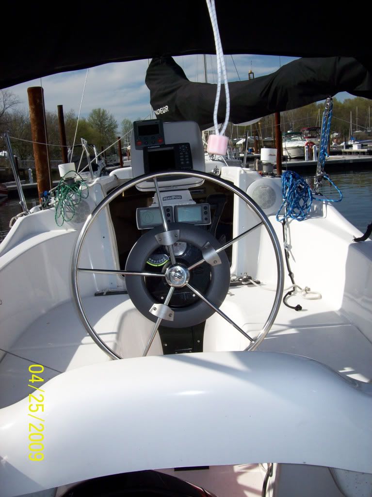
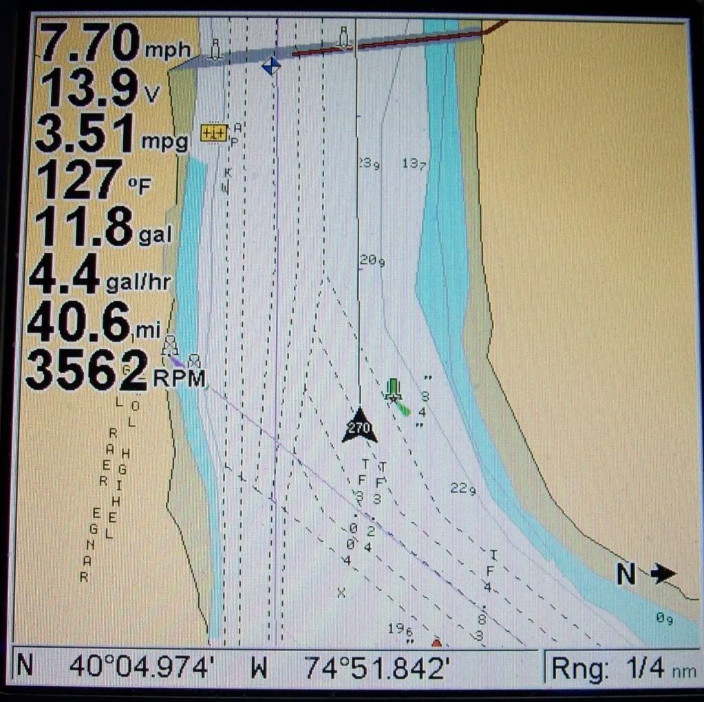
http://i151.photobucket.com/albums/s152 ... ited-1.jpg ---on Console
http://i151.photobucket.com/albums/s152 ... GPS011.jpg ---- Screen Shot
I always fear owning a high price unit...with having it stolen or breaking
My best advice is go for as high of a resolution as you can afford regardless of the brand...
http://i151.photobucket.com/albums/s152 ... ited-1.jpg ---on Console
http://i151.photobucket.com/albums/s152 ... GPS011.jpg ---- Screen Shot
-
Chinook

- Admiral
- Posts: 1730
- Joined: Sun Feb 26, 2006 7:20 pm
- Location: LeavenworthWA 2002 26x, Suzuki DF60A
Re: Chartplotter?
When I bought my Garmin 188 in 2002 I opted for the black/white screen, partly due to higher cost for the color screen, but also because I was told at the time that the color models used power at a higher rate. I wonder if there have been changes in rate of electrical usage with color vs black and white screens. Color would be nice, but I've gotten used to the b/w, and I'm always interested in being able to stretch my batteries.
-
Kelly Hanson East
- Admiral
- Posts: 1786
- Joined: Sat Apr 19, 2008 2:35 pm
- Sailboat: MacGregor 26X
- Location: Kelly Hanson Marine........Mac 26M Dealer......Freedom Boat Works
Re: Chartplotter?
Randy - I think CPs break into two genres..
1. Those who just want to record our passages electronically
2 Those who will actually navigate with the CP.
I dont think lake sailing ever really gets you to genre (2) - although I know GSL is really a fresh water ocean, the point is near shore you cant rely on a CP anyway.
I do a combination of both lake and coastal (<20 miles offshore) and use a handheld plotting GPS (Garmin 76CS at about 300 USD)
For a slipped boat, the ability to take your expensive GPS with you is the best theft deterrent there is.
-
c130king

- Admiral
- Posts: 2730
- Joined: Sun Nov 05, 2006 5:30 pm
- Sailboat: MacGregor 26M
- Location: Wiggins, MS --- '05 26M "König" w/ 40hp Merc
- Contact:
Re: Chartplotter?
I also use a Garmin...the GPSMap 478. I liked it because it came with built-in coastal US charts, also has built in US Street Maps and works as an automotive GPS, and was seemed very easy to use. It only has a 3.8" screen but it is very bright and easy to read (at least to me)...the size is good for me as it mounts effectivey on top of the pedastal and doesn't take up too much space.
I have had it for three years now of constant use in my boat and in my car over here in the UK (I did pay $300 for the European Road Maps and a 500KB memory card) and have never had a problem. I have replaced the 12- volt cable as I broke my first one but parts were easy to find.
I am happy with Garmin and will probably stick with them in the future.
Just another viewpoint to consider.
Cheers,
Jim
-
Sumner

- Admiral
- Posts: 2375
- Joined: Sun Jan 04, 2009 3:20 pm
- Sailboat: MacGregor 26S
- Location: SE Utah
- Contact:
Re: Chartplotter?
Maybe I missed it, what do you have?Laika 26X wrote:.............. I loath being at a Mfr's whim when it comes to chart updating, especially when NOAA provides it for free.
I learned how to do that on my unit, for free. Some workarounds to achieve it, but I'm happy............"Sub" Ed
Also do you have any links or a direction to send someone in where they can learn about using the NOAA info?
We have a Garmin Map76 and we are going to get a new radio with DSC and I'm thinking of hooking the present GPS to it full time and getting a new one to use in the cockpit or buy a used one to use with the radio. I'm happy with the Map76 for now in the cockpit with the smaller screen, but something larger might be nice for the future.
Thanks,
Sum
Our Trips ...........
Our Mac Pages
Mac Links
Last edited by Sumner on Wed Dec 09, 2009 11:48 am, edited 1 time in total.
-
Randy McCotter
- Chief Steward
- Posts: 66
- Joined: Tue Jun 28, 2005 12:55 pm
- Location: Slave Lake Alberta Canada..... "Mari-Jacq"..... 2002 Mac 26X
Re: Chartplotter?
Thanks All..... those were all pretty good opinions. I will definately take in consideration. My intended usage is here on Lesser Slave Lake but next summer, I plan to load everything up and haul her out to the coast for a couple of weeks. The plan is to drop in at Lund and then sail over to Comox (vancouver island) to visit a buddy. We will then head over to Desolation sound for a week or so. There is quite a tidal change there so I'd really feel comfortable having a big, reliable plotter. I will have all the appropriate paper charts as well but I really like the convenience of an electronic plotter. I'm sure I'll love it there and want to trailer back down in the future so this is not a one shot deal, several years of coastal cruising are in my future. Still leaning towards the Lowrance..... pretty fancy set up !
I really like Highlanders set up, for all mods. I wonder how much it would cost for some of his professional "talent"? I may have to pick up a new bottle of Auchentoshan 21 !!!!
Randy.
I really like Highlanders set up, for all mods. I wonder how much it would cost for some of his professional "talent"? I may have to pick up a new bottle of Auchentoshan 21 !!!!
Randy.
-
Russ

- Admiral
- Posts: 8305
- Joined: Thu Oct 11, 2007 12:01 pm
- Sailboat: MacGregor 26M
- Location: Bozeman, Montana "Luna Azul" 2008 M 70hp Suzi
Re: Chartplotter?
Lot's of great choices out there as well as opinions.
My boat came with a Garmin 400sx and I LOVE it. Some may have better choices..but from my limited experience... this thing rocks. Pretty cheap nowdays as well.
My 2 cents.
--Russ
My boat came with a Garmin 400sx and I LOVE it. Some may have better choices..but from my limited experience... this thing rocks. Pretty cheap nowdays as well.
My 2 cents.
--Russ
-
Laika 26X
- Engineer
- Posts: 159
- Joined: Mon May 11, 2009 12:42 pm
- Sailboat: MacGregor 26X
- Location: Homeport: Mt Sinai, NY - Homewaters: Long Island Sound, Northeast USA
- Contact:
Re: Chartplotter?
Randy,
Good luck on your final choice. FWIW, I did neglect to point out that my final choice was between both Lowrance and Garmin as well. I went with the Garmin not only because it suited my aforementioned requirements, as did the Lowrance, but a recent PRACTCAL SAILOR http://www.practical-sailor.com/ issue indicated the sonar display was better on the particular model GARMIN I was looking at. Finally, I had owned the GARMIN 188 for 7 seasons and am used to GARMINs quirks. FWIW, I actually prefer the older 188 interface than the 540s I own now. I like specific buttons for specific functions as opposed to menu hunting which others may prefer. BTW, the resolution was the same as the 188, and that was fine for me in lieu of the 545 series and the increase initial outlay of funds.
Sumner,
Garmin 540s
Check out my mods on how I integrated to my DSC Radio and Alarm Feature. Easy stuff.
Read on about the use of NOAA RNC's and GARMIN units: (Warning, most may realize now I get wordy)
I don’t like creating waypoints and routes on the Chartplotter itself. I prefer sitting comfortable at a PC with a real keyboard and mouse to manipulate my Navigation Data. The GARMIN database, UserData.ADM, is a proprietary database file. This is the file that can be saved to an SD Card for backup. The issue is, other than Garmin’s proprietary Software (like Trip and Waypoint Manager), you can ONLY create/edit Waypoints/Routes on the Chartplotter itself.
However with a program called GPS Utility http://www.gpsu.co.uk/index.html
to convert the file, you can convert it to other formats that can be read by other apps, like Google Earth or even a text file that can be read into EXCEL and manipulated as well. There is a free version and a full blown version for $60 US.
Now obtain the free charting software such as SeaClear http://www.sping.com/seaclear/ This is the program that will view the free RNC Charts that can be downloaded from NOAA http://www.nauticalcharts.noaa.gov/staf ... spubs.html It’s not the most user friendly software, nor does it have a great manual. But once you installed the charts, it does the job and you get used to it fairly quickly. Another good feature is that you can print the charts out! Put them in a binder and keep onboard. Free charts, updated when you want without leaving your house!!
Now you can download the latest charts for your area. Transfer your GARMIN data to SeaClear. Add/Change/Delete Waypoints and Routes to your hearts content at home, at work, day or night.
Wrap it up, and transfer it back to your Chartplotter.
Passage planning from your local creek to next year’s great adventures has never been easier. Think of all the other recourses available for you at your PC than on the boat with the plotter itself. Granted you can bring your laptop with/WIFI to the boat and have those resources, but you’re still using the GPS to add/change/delete waypoints/routes. As a former USN QM, I prefer working with NOAA charts when planning. Plus it’s a second source of Navigational information; I’ve seen the differences between my GARMIN’s built in Cartography and the latest edition NOAA Charts. What’s neat too is that with GPS Utility, your Tracks are converted as well. At the end of your season, convert that to Google Earths KML file for a record of your yearly sailings!
Finally, while you’re still really at GARMIN’s mercy when it comes to updating the built in charts, you can still review it to the downloaded charts, and either mark ATON changes with special waypoints, or simply decide whether you should pay the $80 or so for the upgrade. I mean, if nothing’s changed in the areas YOU frequent, why update for that year? But if you do plan to go out of you normal “waters”, the software upgrade is always prudent and recommended. Your choice, your comfort level.
-
Russ
- Admiral
- Posts: 8305
- Joined: Thu Oct 11, 2007 12:01 pm
- Sailboat: MacGregor 26M
- Location: Bozeman, Montana "Luna Azul" 2008 M 70hp Suzi
Re: Chartplotter?
Where we boat we don't need a chartplotter. It's a lake and you can't really get lost and we don't have fog. But despite the size of the lake (30 miles long) I could not for the life of me find any charts anywhere. This little chartplotter (Garmin 440sx) has them. It's mostly a toy for me, but it's a fun toy to be able to see exactly where I am. At night, it's pitch pitch black on the lake and I couldn't find my way back into a cove without it.
The depth finder feature is fun as well. Some find the interface more complicated than others, but I have no trouble with it.
We removed it and put it below when we're gone. I even bought an extra DC cable and I can bring it to another boat (or car). Silly little toy but it's my favorite one on the boat.
--Russ