Page 1 of 2
Winnipesaukee question
Posted: Fri Nov 10, 2006 5:42 pm
by CFCassidy
For those that are familiar with boating on Lake Winnipesaukee, is it possible to take a Mac 26X between Paugus Bay and the big Lake?
Posted: Fri Nov 10, 2006 9:24 pm
by kmclemore
Yes, I believe it is possible, although I've not gone there personally. I know that Thurston's Marine and Channel Marine are just on the other side of the bridge going into Paugus Bay, though, so it must be a pretty navigable channel. However, I think Catigale or Chuck Healey are probably your experts in that neck of the woods... I only go there as a visitor.
One suggestion, though... if you're gonna navigate Winni, I *strongly* suggest getting a
Bizer map, or, if you have a C-Map compatible chart plotter, get the Bizer cartridge. It's the best navigation tool for that lake and no boater should be without one. It has virtually every rock and landmark on the lake in that chart - excellent stuff. I have a Standard Horizon 155C and the C-Map works a treat, but if you don't have C-Map capability, at least get the waterproof paper chart - at only $14 including shipping it's a great deal.
One amusing note - the Bizer chart is filled with fun little things - like on Mirror Lake the writing is mirrored, and there are hidden messages for Bizer's kids and such on the map, too. Makes for fun reading in the evening. (OK, so I was bored).
Posted: Fri Nov 10, 2006 9:42 pm
by kmclemore
Here's a picture of the bridge going into the bay.. you can see it's pretty high and navigable. It's from the Thruston's Marina website and that's their red barn on the right.

Posted: Sat Nov 11, 2006 5:18 am
by CFCassidy
Does the Bizer chart show the bridge height?
I'm contemplating a move to the Winnipesaukee area and so am looking at housing/boat dockage options. There are a lot of nice properties right on Paugus Bay.
Posted: Sat Nov 11, 2006 6:00 am
by K9Kampers
Yes, you can navigate a Mac 26X thru the Weirs channel between Paugus Bay and the big lake, but not with the mast up. For as many times as I have gone under that bridge, I've not had to consider the height from a sailors perspective. The channel is adequately wide and deep enough for two lanes of boats and is VERY busy on summer weekends.
However, the Bizer chart lists the bridge clearance at 21 ft. Heights are based on "full pool" which is 4.32 ft. above "lake datum". Full pool is the target height for spring. "Lake datum" is the zero point of a gauge at Weirs Beach and is 499.92 feet above sea level.
A typical (Bizer) lake level for this time of year before the water turns hard, is about 503 ft. This would give 22 ft. thru which to navigate a 33ft. tall vessel. But now, isn't this just one reason why we have Macs?
Posted: Sat Nov 11, 2006 3:47 pm
by kmclemore
BTW, Bizer also tracks the lake's height - you can find them
here.
And BTW, please note the following:
Jun-04 - The USGS has adjusted its datum of Lake Winnipesaukee from 499.92 feet above sea level to 500.00 feet above sea level. Please add 0.08 feet (one inch) to all comments with respect to above sea level (ASL). Full lake, formerly 504.24' ASL is now 504.32' ASL.
Posted: Sun Nov 12, 2006 4:09 am
by Catigale
Ill stick this one into Events and Venues for reference when you guys are done adding..good luck with the 'transition], Charles.
Posted: Sun Nov 12, 2006 7:29 am
by kmclemore
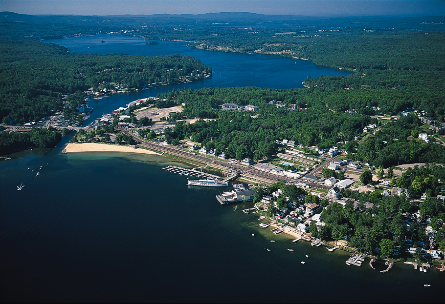
Better views of the Weirs Channel leading into Paugus bay (Note the
"Weirs Drive-In" movie theater on the left - it's still active!):
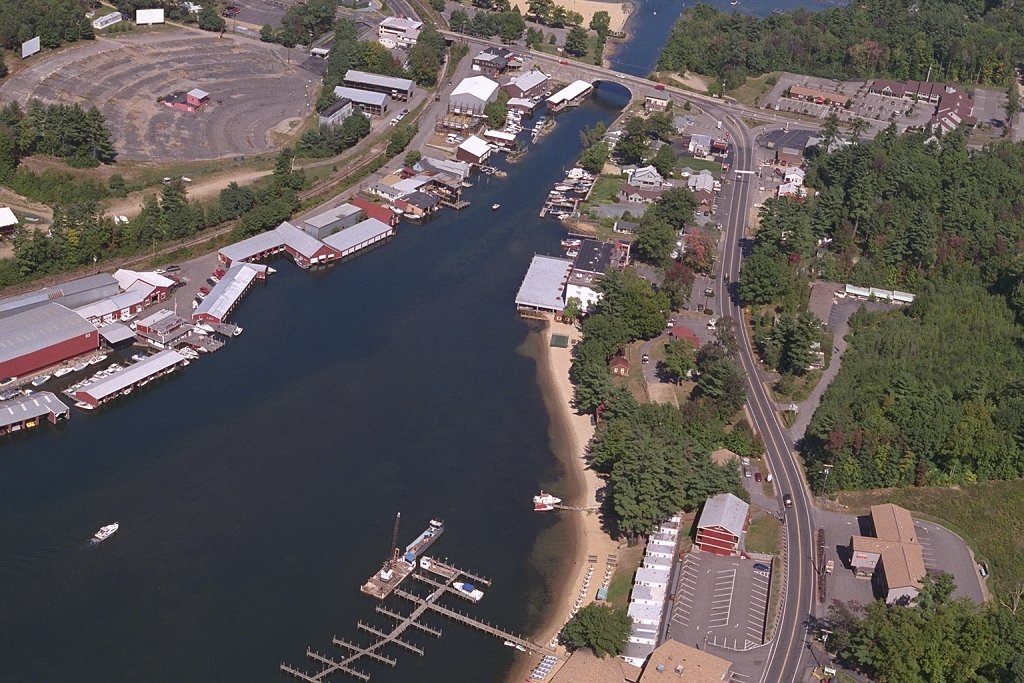
This one must have been taken on a Saturday afternoon... it goes to prove your point, K9Kampers - it's definitely a busy channel! (I count around 70 vessels in the channel in this pic):

And a close-up picture of the channel, taken from the bridge on a quiet day, looking down into Paugus Bay.... Thurston's Marina is on the right.

Other nice photos of Paugus Bay may be
found here.
Posted: Sun Nov 12, 2006 6:00 pm
by Chuck Healey
I have been "out of the loop" and havn't checked the board in a while. K9Kampers is correct, the Weirs channel bridge can only be navigated with the mast down. Last Fall I decided to take a trip through the channel, since my mast was already down and the boat set to trailer home. Due to the high lake level at the time, I was surprised to find a pretty strong current running through the channel. As Kevin pictures show, it does get very busy on weekends in the Summer.
I wish you luck in relocating to the Winnipesaukee area. It's a great lake to sail on, but I havn't seen too many other Macs (except for the classics) on the lake. I was able to meet Kevin this Summer, when he and his wife were staying on their X in Moultonborough Bay. We also have the NE-TS Winipesaukee redezvous on the lake every May. Other than that I havn't ran into too many other Macs on Winni.
Moorings and slips on the lake are very hard to come by and are therefore priced accordingly. I keep my X on the trailer, mast up, at Ames Farm in Gilford. Last year it was $850 for the season. It's less convenient than a slip or mooring, but much less expensive.
I have noticed there were some lakefront properties on Pagus Bay that were selling for quite a bit less than properties on the big lake. If you dont mind bringing your mast down to get under the bridge, it might be worthwhile. I was actually toying with the idea of finding a slip or mooring on Paugus Bay, since I live only about a block from the South end of the bay in Lakeport.
Posted: Mon Nov 13, 2006 6:59 am
by K9Kampers
Nearly 20 years ago, a group of us did a winter drift dive (SCUBA) in the Weirs channel. We entered near Endicott Rock and just went with the current, getting out down near Channel Marine. I remember the depth under the bridge being 12 feet or so. I filled a mesh bag full of old bottles that I picked up off the channel bottom that were marked as being bottled in Laconia, as well as other New England bottlers. Still have most of them.
Chuck -
I haven't seen any other Macs on the big lake either. I tend to keep to the southern end of the lake - from the north end of Rattlesnake down to Alton Bay, usually launching out of Wolfeboro. On no wind days I've motored up to the Little Bear Isl area and Weirs Beach. I have met many Mac enthusiasts at the Wolfe docks, both local and from away.
Posted: Mon Nov 13, 2006 7:39 am
by kmclemore
Chuck Healey wrote:...I was able to meet Kevin this Summer, when he and his wife were staying on their X in Moultonborough Bay. ...
It was great seeing you, Chuck! You have a very well kitted boat.
I'd love to get up there for that annual NE-TS get-together but it always falls at the wrong time of year for us... if only it would take place in August... besides, it's warmer then! (.... or at least during the summer holiday sometime... tough to make it up there when the boys are in school.)
K9Kampers wrote:Nearly 20 years ago, a group of us did a winter drift dive (SCUBA) in the Weirs channel.
I thought the lake freezes over in winter... must have been a bloody cold dive!

Posted: Mon Nov 13, 2006 8:06 am
by K9Kampers
Yes, the lake does freeze over, & yes it was a bloody cold dive. However, the Weirs channel is always open due to the current.
Most of my winter diving was done in a wetsuit, ice diving on the lake and scallop diving in the ocean. A few dives I made with a drysuit. But those ice cream headaches at depth...ooohhhhhh!!

Posted: Mon Nov 20, 2006 4:42 pm
by CFCassidy
Thanks for all the information and the wishes. It looks like I did not get the job. I guess you can move the thread now (sniff, sniff

).
Posted: Mon Nov 20, 2006 5:44 pm
by Catigale
Having had a look at your CV and knowing a bit about working in those fields and companies, I would say its their loss

Posted: Tue Nov 21, 2006 1:05 am
by Frank C
CFCassidy wrote: ... It looks like I did not get the job. I guess you can move the thread now (sniff, sniff
).
Bummer Charlie, but it just means you're still available for somethin' better. All the best.
Mod's note: Thread has really good skinny on Winnie ... moved to Events/Venues. fc