

I have to admit your journey has been on my mind these past few days during the black out period of your trip. Great to hear you are doing okay.
Looking forward, as usual, to reading about your experiences.
--Russ
Back on the water again, finally.......off to the Bahamas
-
dlandersson

- Admiral
- Posts: 4948
- Joined: Fri Aug 27, 2010 10:00 am
- Sailboat: MacGregor 26X
- Location: Michigan City
Re: Back on the water again, finally.......off to the Bahama
To me "36 hours" isn't very clear. 36 hours at 5 knots? Or 36 hours at 15-16 knots? A major plus of the X/M is the ability to haul ass when its a good idea. 
RussMT wrote:mastreb wrote:I don't consider the Gulf crossing to the Bahamas nor the San Pedro Channel crossing to Catalina to be problematic. The depth of the water isn't really a concern, the problem is being caught unaware in a storm you can't do anything about. In both of these cases, a full tank of gas will get you out of harm's way, the weather is stable enough to know in advance whether you can go or not, and they're both short crossings with little risk of unexpected weather.
-
Ixneigh

- Admiral
- Posts: 2469
- Joined: Thu Sep 09, 2010 11:00 am
- Sailboat: MacGregor 26M
- Location: Key largo Florida
Re: Back on the water again, finally.......off to the Bahama
Sumner is making good time. I'd still be at chub cay.
Ix
Ix
-
cptron

- Captain
- Posts: 515
- Joined: Wed Mar 28, 2012 11:08 pm
- Sailboat: MacGregor 26M
- Location: Hattiesburg MS. "Storm Walker" 2011 26m with ETech 60
Re: Back on the water again, finally.......off to the Bahama
+1Chinook wrote:Hey Mon,
Good to hear from you. You've really been moving. Looking forward to hearing about where you stopped, and how your passages went.
Say, if you get tired of the beautiful weather and beaches over there, I am hosting another annual Southport Sail, May 8-10. You should come join us.
Re: Back on the water again, finally.......off to the Bahama
All right put on those shads and chill out for the Trades to settle down
-
BOAT

- Admiral
- Posts: 4969
- Joined: Fri Oct 19, 2012 5:12 pm
- Sailboat: MacGregor 26M
- Location: Oceanside, CA MACMJ213 2013 ETEC60
Re: Back on the water again, finally.......off to the Bahama
Geeeze you guys, I'm still trying to figure out where Georgetown is . . . . . 
-
ris

- Captain
- Posts: 705
- Joined: Sat Feb 28, 2015 4:27 pm
- Sailboat: MacGregor 26X
- Location: Frostproof Florida
Great to hear from you
Glad things are going ok. I was begining to wonder if you took a wrong turn or something. Thanks for posting.
-
Russ

- Admiral
- Posts: 8314
- Joined: Thu Oct 11, 2007 12:01 pm
- Sailboat: MacGregor 26M
- Location: Bozeman, Montana "Luna Azul" 2008 M 70hp Suzi
Re: Back on the water again, finally.......off to the Bahama
You see there is another ocean on the right coast, the ATLANTIC Ocean.....BOAT wrote:Geeeze you guys, I'm still trying to figure out where Georgetown is . . . . .
Here
https://www.google.com/maps/place/Great ... 00c0e36c91
The man is solo sailing a 26S. He's closer to Cuba than the United States.
I'm not sure where Sumner is, but the brochure sure looks nice.

Or maybe he's swimming with the pigs
https://www.youtube.com/watch?v=O89DvVdthDY
-
Chinook

- Admiral
- Posts: 1730
- Joined: Sun Feb 26, 2006 7:20 pm
- Location: LeavenworthWA 2002 26x, Suzuki DF60A
Re: Back on the water again, finally.......off to the Bahama
Sum's boat is a 26S, and not designed to go faster than 6 or 7 knots, tops. Where Sum is cruising, he's got some stretches where fuel docks are more than 100 miles apart. If you push an X or M fast, you'd need 40 to 50 gallons of gas to make it, and fuel down there is probably over $6/gallon. The high speed advantage of the X/M isn't worth much when on an extended cruise.dlandersson wrote:To me "36 hours" isn't very clear. 36 hours at 5 knots? Or 36 hours at 15-16 knots? A major plus of the X/M is the ability to haul ass when its a good idea.
-
dlandersson
- Admiral
- Posts: 4948
- Joined: Fri Aug 27, 2010 10:00 am
- Sailboat: MacGregor 26X
- Location: Michigan City
Re: Back on the water again, finally.......off to the Bahama
Gotcha...if I can haul ass when its a REALLY good idea - $6 a gallon is a cheap price for my and my family's health and safety.
Chinook wrote:dlandersson wrote:To me "36 hours" isn't very clear. 36 hours at 5 knots? Or 36 hours at 15-16 knots? A major plus of the X/M is the ability to haul ass when its a good idea.
Sum's boat is a 26S, and not designed to go faster than 6 or 7 knots, tops. Where Sum is cruising, he's got some stretches where fuel docks are more than 100 miles apart. If you push an X or M fast, you'd need 40 to 50 gallons of gas to make it, and fuel down there is probably over $6/gallon. The high speed advantage of the X/M isn't worth much when on an extended cruise.
-
Sumner

- Admiral
- Posts: 2375
- Joined: Sun Jan 04, 2009 3:20 pm
- Sailboat: MacGregor 26S
- Location: SE Utah
- Contact:
Re: Back on the water again, finally.......off to the Bahama
Right nowChinook wrote:Hey Mon,
Good to hear from you. You've really been moving. Looking forward to hearing about where you stopped, and how your passages went.
N 24--06.078
W76--23.973
and the wind is howling out there and suppose to run at times over 20 kts the next 3 days or so. About that when I came in here right at the edge of a squall. Was in a squall for 45-50 minutes on the Banks and it seemed more like 4 hours. That 105 mile crossing--25 hours from Bimini to Whale in the Berry's was a long day and night that I hope to not repeat.
Had to stay at Whale for about 5 days due to high winds and then left a day before I should of and the 45 miles down to Rose Island by Nassau took all day slogging along into the waves and wind. Not a fun day but I have a lot better idea what the Mac can take. More than you are comfortable with but it never felt unsafe.
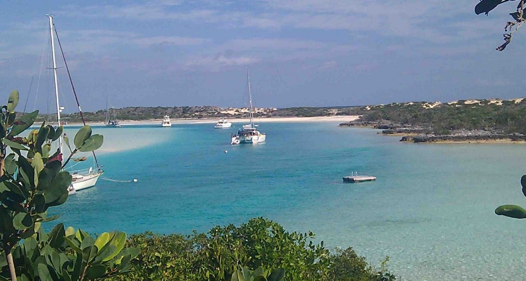
From Rose to Pimlico (northern Exumas) was all sail except the last miles when the wind got to be too much on the nose. Started a tack back to gain ground but was running out of daylight so motored on in. Really liked it there all alone. Spent two days, one fixing and servicing things on the boat. Then onto Allan Cay and anchored where you did for 2 days but wouldn't anchor in that south bay again where the Iguanas are as there is too much traffic in to see them. I was sure someone was going to end up with my rode wrapped around their prop. One boat came in right off my bow with five 350 HP Yamahas on it (only two running at the time.)
Left there and went to Highborne where I had hoped to get some wifi. Their wifi for poor transits like myself was down and they wouldn't let you on the wifi for 'guests'. Spent $200 there on 16 gallons of gas and 4 small, very small, bags of groceries and they wouldn't even let me send out one stinking email. Started to worry that family would be worried as I hadn't had any contact since Bimin so decided to run down to Staniels Cay where there was suppose to be wifi. Made a little over 50 miles but sailed over 40 of that with the outboard up. Great day but then saw the big clouds and went in at Sampson just short of Staniels. Hit the edge of a squall there but nothing like the Banks as I was on the edge. Nice anchoage just off a private beach but no wifi. Then this morning there on the radio I asked about wifi and found out you pay at Staniels, which would of been ok but one guy told me about here, Rock Point, where it was free so I sailed here except the last 2 miles when another squall was going by and the winds really piped up so thought I'd better quit screwing around and get in here. Nice place and it is suppose to be very friendly. I'm using my long distance wifi from the boat and it is working great. Tried calling out on Skype and they couldn't hear me but I could hear them so not quite fast enough for that.
So I'm moving south faster than planned but felt I needed to make contact with family so now I think as soon as this next system is done I'll move on down to Georgetown in 3 jumps from here. I don't think I'll want to stay there long but want to know I made it. Then I'll work back up in a slower fashion stopping at a number of the places I've sailed by.
I'd like to jump from the upper Exumas over to Current off of Eleuthera and from there to Sandy Point on Great Abaco and then cross the Bight of Abaco and the Little Bahama Bank to West End and over to Florida the end of May. So I have a lot of time to think about things. Need to get to bed so I can get up at 6:30 and listen to Chris' weather report,
Sumner
P.S. 638 Miles since I left the boatyard on March 9th.
============================
Our MacGregor 26-S
Our Endeavour 37
Our Trips to Utah, Idaho, Canada, Florida
Mac-Venture Links
-
Chinook
- Admiral
- Posts: 1730
- Joined: Sun Feb 26, 2006 7:20 pm
- Location: LeavenworthWA 2002 26x, Suzuki DF60A
Re: Back on the water again, finally.......off to the Bahama
Hi Sum,
Crossing the Banks is a long passage under the best of conditions. Sounds like you had anything but. Glad you made it to Whale without mishap. As you view your charts heading down to Georgetown, you can go further south on the inside than the bigger keel boats can. I went through the last cut to the outside (don't recall the name). It's worth paying attention to the tide and current when trying to exit any of those southern cuts. The current can run very strong through them, and some large standing waves can take shape. With your smaller outboard, you will have difficulty pushing through against a flood current. You'll only have 12 to 15 miles of outside sailing on the final approach to Stocking Island. You'll want to be on top of your charts when entering the cut to get into the Georgetown harbour. Big reefs with nasty breaking waves on either side, but plenty of room down the middle. It's a good idea to set a waypoint where you'll want to turn when entering the cut. Good luck on your run to Georgetown. Incidentally, there's no fuel dock there, so you'll need to dinghy your portable gas cans to the dinghy dock on Lake Victoria, and then walk a short block over to the gas station. Good free water at the dinghy dock for cruisers, and a good grocery store right at the head of the dinghy dock. Free wifi in that general vicinity too. I hope you've seen the last of those nasty squalls. We wish you good luck and fair winds.
Crossing the Banks is a long passage under the best of conditions. Sounds like you had anything but. Glad you made it to Whale without mishap. As you view your charts heading down to Georgetown, you can go further south on the inside than the bigger keel boats can. I went through the last cut to the outside (don't recall the name). It's worth paying attention to the tide and current when trying to exit any of those southern cuts. The current can run very strong through them, and some large standing waves can take shape. With your smaller outboard, you will have difficulty pushing through against a flood current. You'll only have 12 to 15 miles of outside sailing on the final approach to Stocking Island. You'll want to be on top of your charts when entering the cut to get into the Georgetown harbour. Big reefs with nasty breaking waves on either side, but plenty of room down the middle. It's a good idea to set a waypoint where you'll want to turn when entering the cut. Good luck on your run to Georgetown. Incidentally, there's no fuel dock there, so you'll need to dinghy your portable gas cans to the dinghy dock on Lake Victoria, and then walk a short block over to the gas station. Good free water at the dinghy dock for cruisers, and a good grocery store right at the head of the dinghy dock. Free wifi in that general vicinity too. I hope you've seen the last of those nasty squalls. We wish you good luck and fair winds.
-
Ixneigh
- Admiral
- Posts: 2469
- Joined: Thu Sep 09, 2010 11:00 am
- Sailboat: MacGregor 26M
- Location: Key largo Florida
Re: Back on the water again, finally.......off to the Bahama
Hahaha highborne yep. Beh.
Re crossing to rose island that's provably why I'd still be at chub. I'm too much of a pansy to make that crossing when it's crppy. The good thing is this time of year it's all a nice downwind ride from grand exuma back home. Farmers cay was a nice stop btw. Rudder cut is the cut that's pretty hairy.
For my next trip I intend to get one of those spot communicators so I can update with brief txt messages to people back home.
Best
Ix
-
Sumner
- Admiral
- Posts: 2375
- Joined: Sun Jan 04, 2009 3:20 pm
- Sailboat: MacGregor 26S
- Location: SE Utah
- Contact:
Re: Back on the water again, finally.......off to the Bahama
Hi, you went out on the north side of Soldier Cay I believe. There is also a cut on the south side and one is better in north winds (south one) and the one you took in east winds according to Explorer Charts. There is also a cut about 2 miles north of there at Glass and Black Cays with the same two options but it looks like laying over there on anchor has more surge. I'll use one of these but for sure it will be at slack time with my boat/motor combination and I'd like to if possible go in Stocking Island on the next tide change also or close to it.Chinook wrote:...... As you view your charts heading down to Georgetown, you can go further south on the inside than the bigger keel boats can. I went through the last cut to the outside (don't recall the name). It's worth paying attention to the tide and current when trying to exit any of those southern cuts. The current can run very strong through them, and some large standing waves can take shape. With your smaller outboard, you will have difficulty pushing through against a flood current. You'll only have 12 to 15 miles of outside sailing on the final approach to Stocking Island. You'll want to be on top of your charts when entering the cut to get into the Georgetown harbour. Big reefs with nasty breaking waves on either side, but plenty of room down the middle. It's a good idea to set a waypoint where you'll want to turn when entering the cut. Good luck on your run to Georgetown. ....
On the waypoints I always have them in the handheld and the computer running OpenCPN just in case one or the other went down. They are also connect so I can quickly send new waypoints to the handheld in seconds. For instance I had the waypoints in the other day for Hightborne to Staniel loaded into both but when it looked like that might take to long I added a route with OpenCPN into Sampson and then when I needed to go in there a few clicks on the handheld deleted the waypoints to Staniel and two mouse clicks on OpenCPN sent the new ones to the handheld. I'd strongly suggest that anyone thinking of making this journey have two chart plotters up and running just in case one goes down at an in opportune time. I have two sets of paper charts but it would be hard to navigate into some place here using them unless I knew exactly where I was when I lost the chartplotter. I also have a netbook and a laptop on board with OpenCPN and the charts loaded on them just in case the computer I made and use went down.
As you know you are really on your own here, sometimes not seeing other boats for hours and the Coast Guard is not going to come get you and if you push the DSC button on the radio maybe no one will hear it. One should have good navigational skills and a lot of trust in the boat and themselves to get out of trouble if it happens because you are alone a lot. It isn't like being in the states. You might have to hole up for a week if conditions really get bad and you need to have the mind set that you are there by yourself and are prepared mentally to deal with that.
Thanks for the info on fuel there. As you know I carry enough between the inboard tank (20 gallons) and 3 containers and one in the dinghy (14 gallons) that I have a range of over 300 miles but like to stay topped up when I can get it so if I have to go a long ways I'm ready. So far I had filled up at Key Largo (thanks to Ixneigh) and then got 5 gallons at Bimini and 16 gallons at Highborne.
Talking about Highborne and a few other places the charts have the names spelled one way and the locals or guide books a different way. My charts (NV and Explorer) spell it Highborne but when you are there their internet is Highbourne?? Same at Allan, found it spelled Allan and Allen??
Sumner
Our MacGregor 26-S
Our Endeavour 37
Our Trips to Utah, Idaho, Canada, Florida
Mac-Venture Links
-
BOAT
- Admiral
- Posts: 4969
- Joined: Fri Oct 19, 2012 5:12 pm
- Sailboat: MacGregor 26M
- Location: Oceanside, CA MACMJ213 2013 ETEC60
Re: Back on the water again, finally.......off to the Bahama
Hey, I finally found it on a map! Wow, that's a long way out into the ocean! I wonder if Mr. Sumner saw those swimming pigs that Russ was talking about.