Hmmm . . Things have changed over the years.
I have been using navigation software for quite some time. There are some really expensive iridium sat programs to help find the best course through the wind as you plan a long leg from say, Long Beach to Hawaii. These systems give you the wind direction and speed across your entire leg and calculate base on real time what you wind position will be at any given point along your route. Because we now have computers the size of cell phones it's possible for navigation software to plot where you approximately will be at any time along your route based on the tack you should use for the wind at that exact time of the day without the need of expensive iridium receivers. Since my travels are all within 100 miles of the coast I can use the internet to get similar results.
We all set a course but we also know that the wind will change what we do. By knowing what the wind will do ahead of time you can predict what will happen - let me give an example:
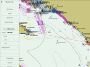
Here is the standard route to Avalon from Oceanside - been doing this route for years - it's like a milk run for me. This is the standard route I always start with - this route is in my plotter at all times:
Alas, but what happens when I set off at zero 800? I find the best wind and it sets me out to sea away from the island:
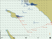
What is nice about the software is that it knows what the wind will do for the entire day and it shows me ahead of time that I will be making a broad tack out to sea because a wind change at around 1803hours (near 6PM) will give me a straight shot downwind to Avalon and as we all know - our MAC boats love to sail downwind - the polars for 'boat' are loaded into the software so it knows that and plotted the tack at 18:03 accordingly as you can see in the top of the screen shot above.
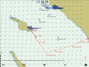
Then here at 2200 hours in the dark you can see the gentle winds giving 'boat' a nice comfortable downwind push into the sleepy harbor town of Avalon:
Now, understand - this is just an example - in reality I may not make such a wide tack or I might go north towards Dana Point and then decide at dusk depending on conditions if I will continue crossing to the island in the dark or dive into Dana Point Harbor for the night and then resume in the morning. The nice thing about the wind GRIB and the polars working together with real time weather data makes the changes on my plotter instantly as my course changes and also as conditions change.
Polars are not just for racing - they are great tools for navigation and plotting.
I hope I have not been to long or bored you guys - I'm trying to get you to understand why I want better polars for 'boat'. (For the past two years I have been using polars for a Catalina 22 and a Jensen 24 depending on my point of sail).


