Rumdirty wrote:Russ, Cedar Creek is the creek just up from the lagoon I come out of. I'm south of the route 72 bridge. I've already been eyeballing that entire area for exploratory purposes. I have no idea how bad Sandy changed things since they were last charted. I'll be honest, I haven't even picked up a chart of the area yet but want to. I'll probably keep away from the north shore area during weekends. Either that or stay in power mode so i don't get run over.
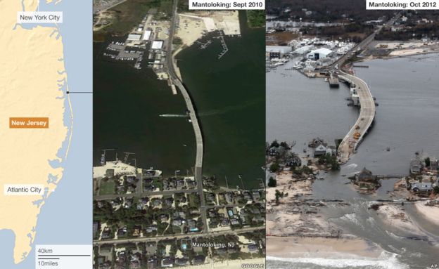
Hmmm... Sandy. Good point. I haven't out there since Sandy. I wish they left that new inlet at Mantoloking

Sure would have saved time getting out to the ocean. I heard cars were washed out into the bay and folks were scanning the bay bottom marking objects for later removal. Who knows what's out there now.
I drove by Mantoloking in June of 2013 and it was creepy to see. Like a weird science fiction war movie with million dollar houses turned sideways. Many totally gone.
Sailing isn't that difficult or else few people would do it. In the bay it's hard to get into trouble. It's 8' deep at most and storms aren't that common, although I've been in some nasty T-storms in Barnegat bay.
You have the option to trailer the boat to better sailing. I couldn't do that, so getting to NY Harbor for fireworks (never again) meant a long journey out through Point Pleasant canal (a nightmare on weekends or full current) to Manasquan inlet or Barnegat inlet. Once out there, there aren't any places to come back for miles. Still, the ocean is TOTALLY different from the bay in so many ways. Smell, feel, waves, wind.
It is the biggest 26' sailboat you can buy and also take it anywhere by land.
I grew up on Barnegat bay and traveled summers to Block Island and Marthas Vinyard. Lots of opportunity. First you have to get comfortable with the boat. Oh yea, and in NJ you need a boating course certificate to operate a boat. Good idea. I'm still a member or Raritan Bay Power Squadron. Great group of folks but probably too far north for you.
--Russ

 Mac26 came home


